Maptime Boston
Vector Tile workshop
By Niene Boeijen
Niene Boeijen

Web Cartographer & Geo ICT developer
Maptime Amsterdam & Utrecht
Internship Geo Web Visualization
Msc Geo Information Science & Remote Sensing
What the map can be
We make interactive maps and visualizations.
Our expertise is open {source; data; standards}
Our power lies in combining cartography with web technology.
Utrecht, The Netherlands
Maptime
Time for making maps!
Maptime is hands on!


WIFI:
PW:
This presentation
bit.ly/2sA4mly
All materials needed:
https://github.com/maptime-ams/vector-tiles-workshopWhat will we do?
- Presentation.
- Workshop.
- Show and tell.
Goal of this evening!
At the end of this workshop, you will have your own web page with an vector-tile based map! Customized to your liking and creativity! Your web page will be hosted on Github, so you can immediately share your progress with all your family and friends!

Vector tiles!
Let's start from the beginning
- What is a Web map?
- How to make a Web Map?
- From Raster to Vector
- Vector tiles and what they look like
- Standards
- Downloading
- Making yourself
- Hosting
- Visualizing
What is a web map?
Analogue paper maps
| Digital maps | VS | Web Maps |
|---|---|---|
| Data | Tiles, styles and servers | |
| On the computer | View in a browser | |
| Calculate, analyze | scroll, pan, zoom |
openstreetmap.org
google.com/maps
a little History
Digital maps
GIS software
GIS on the Web is not user friendly..
1996 Mapquest first with a web service!
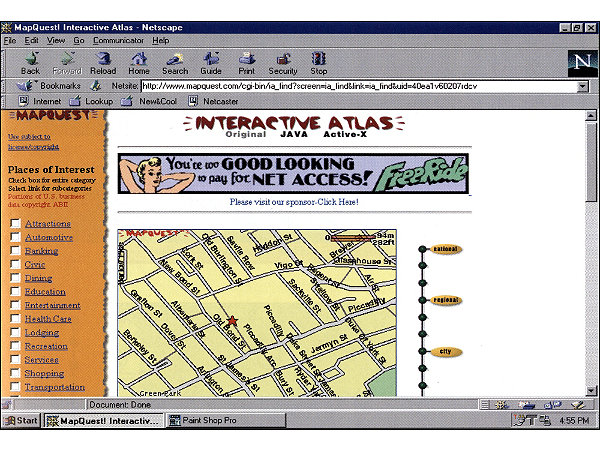
But really slow to load..
in 2004 Endoxon found a way for quick online mapping! map.search.ch
2005 Google Maps took over!
The solution?
Tiles!
Tiles
All tiles size 256x256 pixels
Placed in a grid, sharing boundaries
Seamless map
All these little tiles load way faster than one big map!
We call this slippy maps
Zoom levels
Each zoom level has its own set of tiles!
Zoom level 0: 1 tile for the whole world.
Increases exponentially...
Zoom level 1: 4 tiles
Zoom level 2: 16 tiles
etc.
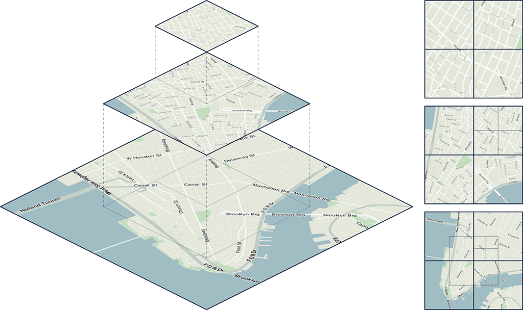 Map with tile bounds
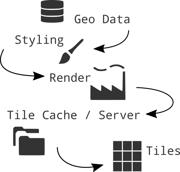
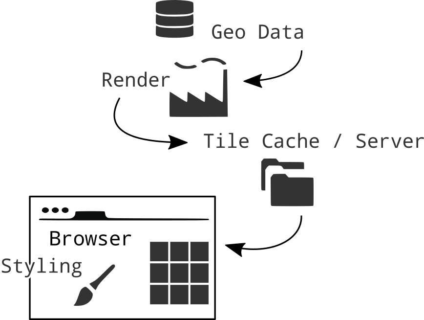
Serving tiles
Tiles are rendered in advance.
Stored in a cache.
Tiles are just images on the web with a url
http://tile.openstreetmap.org/5/16/10.png http://tile.openstreetmap.org/17/67320/43073.png
{z/x/y}
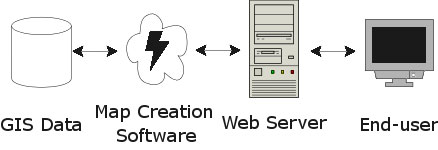
Raster Web Map Building blocks
Data, styled, tiles, server:
Base Layer
Additional Data:
Layers
Interface and Interaction
Zoom, panning, clicking etc.
How to make a Web Map?
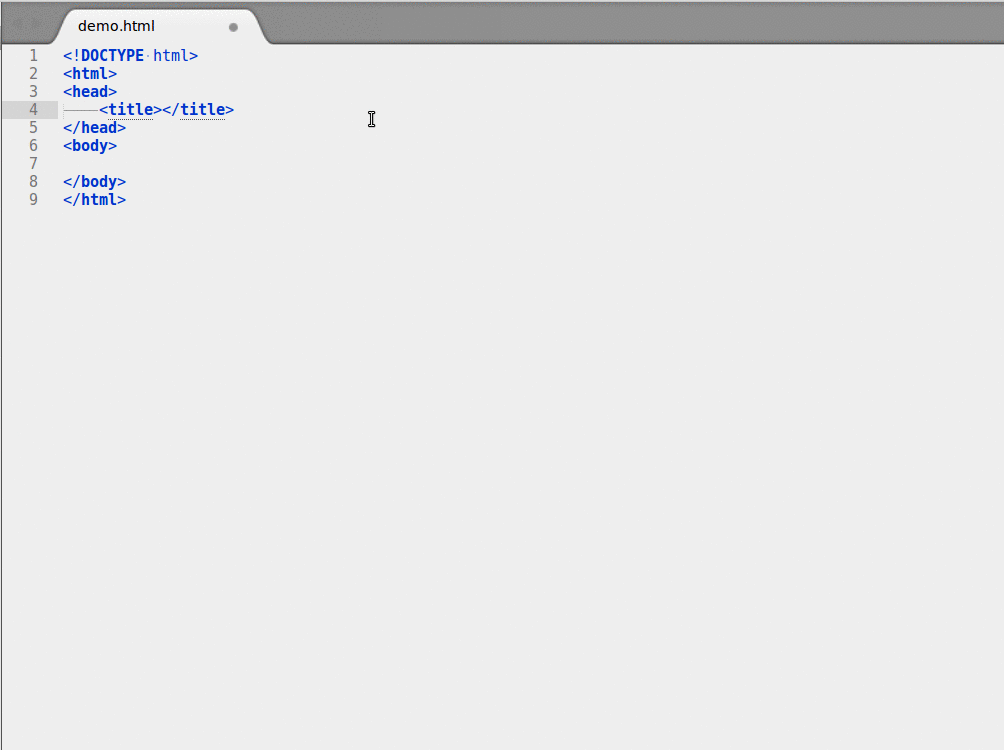
Making a Web Page
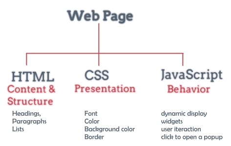
New to HTML & CSS?
Start with Making a web page
Or use Code Academy
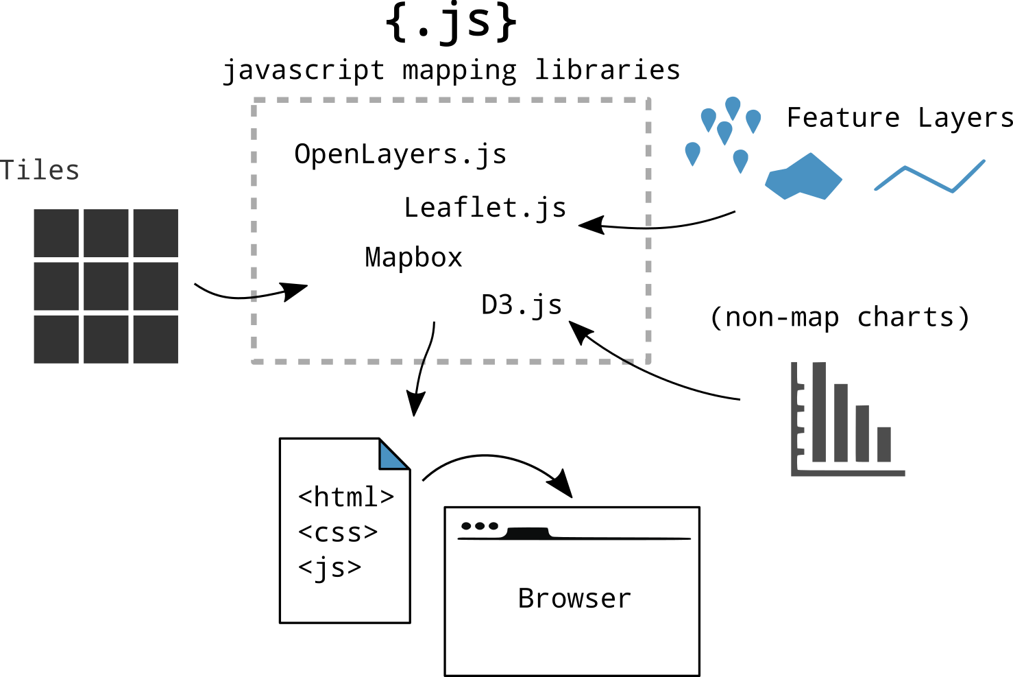
Maps with JavaScript
From Raster to Vector
Advantages Vector tiles
Rendering is done on client side not by the server!
So different clients can style a map different!
Small tile size! So faster data transfer.
High resolution!
Access to feature information!
Maps with JavaScript
Who What Where?
Vector tiles and what they look like.
No colors
Arrays in a 256 x 256 matrix
Same tiling schema as Raster png tiles.
Binary format
Simplifies geometries
Standards
Mapbox Vector Tile Standard.Based on the binary protocol buffer (.pbf) from Google.
Standard already used by Esri.
Web Mercator projection, Google tiling scheme.
Formats
.mvt - .pbf
.mbtiles
Where to get them?
Download
Make with Mapbox Studio
Hosted
Mapzen
https://tile.mapzen.com/mapzen/vector/v1/{layers}/{z}/{x}/{y}.{format}Licenses..
Bake them your self
Host yourself?
Use locally offline
Tile servers
The Netherlands!
NL Amsterdam Datalab.
"https://t1.data.amsterdam.nl/wm/{z}/{x}/{y}.pbf"How to visualize them?
Mapbox studio
JavaScript
Cool stuff!
More info?
Feel free to contact me!
niene.boeijen@gmail.com
Let's get started!

Everything is on Github
Github?!

Used for code.
Version control.
Sharing.
Documentation.
What is in the workshop?
Full code example a map with the Mapbox GL JS library
a testendpoint where to find some tiles
a standard style for you to edit
How to make your own vector tiles
How to download OSM vector tiles
MapboxGL JS
//Initialize Map
var map = new mapboxgl.Map({
    container: "map",
    hash: true,
    style: style_object,
    zoom: 11,
    pitch: 60,
    bearing: 62.4,
    center: [ 4.8, 52.4]
});
Problems or questions?
Use the INTERNET!
Use the MapboxGL JS documentation!
StackOverflow is awesome!
Ask me
Be creative!

There is more to find on the Internet
Do not keep yourself to the assignments!!
The workshop:
https://github.com/maptime-ams/vector-tiles-workshop/wikiThe materials needed:
https://github.com/maptime-ams/vector-tiles-workshopUse the world tiles
Amsterdam tiles contain Dutch words!!
Open Map tile for world map explained bottom section, then scroll up again for the explanations.
Go to https://openmaptiles.com/hosting/ and generate your own free key.